| Wolfgang Michel: Travels of the Dutch East India Company in the Japanese Archipelago. In: Lutz Walter (ed.): Japan - A Cartographic Vision. Prestel-Verlag, München, New York 1993, pp. 31 - 39.
Due to encoding problems some features have been changed. |

|
Travels of the Dutch East India Company in the Japanese Archipelago |
The Dutch East India Company, or Vereenigde Oostindische Compagnie (VOC), was active on the Japanese stage from 1609 onward, initially competing with the "southern barbarians" - as the Iberians were called in Japan - and then briefly with an English trading post. Thanks to their restrained but versatile policies and to their hostility to Spain and Portugal - which had both a religious and a political basis - the Dutch alone succeeded in being exempted from the expulsion of the Europeans after Christianity was banned in Japan. Though the settlement of the "redheads" was forced to relocate from Hirado to Nagasaki in 1641, and though strict limits were imposed on their trade and traffic, their business remained lucrative enough to make a certain amount of interference tolerable. Just as the period between 1549 and 1639 was seen as the "Christian century" of Iberian missionaries and merchants, so did this tiny Dutch trading post of Dejima play a key role thereafter in shaping the European view of Japan as well as the Japanese image of Europe, even into the nineteenth century.
THE IMMEDIATE SURROUNDINGS OF THE TRADING POSTS
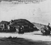
The northwestern coastline of Kyûshû is deeply indented.Jutting islets obscure one's view everywhere; countless reefs and shallow spots can become the doom of inattentive helmsmen in no time. Here, on the island of "Firando" (Hirado), lay the first trading post of the VOC (fig.21) and for this reason the island appears on many maps. One of the first Europeans to contribute to a better understanding of the region was Frans Jacobsz.Visscher. He was not only familiar with the waters of the archipelago as a pilot of the VOC but had also piloted a junk owned by the renowned Suminokura family of merchants, between 1632 and 1634, before Hendrick Brouwer, the VOC's governor of Batavia, gave him the task of improving the maps of the region. His work was widely praised. An example published by Siebold in 1851 shows what these seventeenth-century sketches of the navigable waters around Hirado and Gotô looked like.[1] Documents with this sort of nautical data would certainly have been on board every ship belonging to the Company that called at port in Japan.
From 164l onward, the trading post was on the small manmade island of Dejima ("Disima", "Cisma", etc.) in Nagasaki Bay. It is clear from reading old daybooks that it was no simple task for the skippers to find the entrance to the bay. If one did not miscalculate and was not blown off course by a typhoon, then one could align one's sights on the Danjoshotô group of islands. For that reason, the most conspicuous of the islands, Mejima, appears un nearly all of the old maps, where its name continues to be given in the Portuguese style as "Measima" or "Meaxuma" for some time. In this connection, Kaempfer's all but inexplicahle form - "Matsima" - represented a retrograde step. The next important landmark for helmsmen was the headland of Nomazaki. Nearby was the group of crags called Mitsuse, which the Dutch named "de hen met de kuikens" (the hen with chicks), after its appearance. Now the helmsrnen had to keep a sharp lookoutJ because there followed countless islands and reefs which could only be avoided by sailing to the north of them. Then one spotted off the port bow the steep ascent of the islet Takabokojima, which is referred to as "Papenberg" (clerics' mountain) in many travel books because so many Catholic missionaries are said to have been hurled into the sea here during the time of Christian persecution. The bay quickly narrows thereafter. The observation posts would have long since reported the approach of a ship, and soon the officials of the local governor would come on board. The Japanese fear of religious infiltration was considerable. So, while still at sea, the Dutch captains would collect everything that was of a Christian nature or even bore Christian symbols and stow it in casks or crates. Not even coins were exempted from this measure, since they were stamped with a cross. When the ships lay at anchor, according to Johann Jacob Mercklein, a pharmacist from Windsheim, Germany, writing about his experiences in 1651, "all the people on board were meticulously inspected [and] the names and ages of each of us were recorded, both by the Japanese and by our nation, including by the residing officers; goods, weapons, and ammunition, even rudders and sails, were taken into custody."[2]
The ships of the VOC arrived with the monsoon winds beginning in July. The crews spent most of the time on board while the ships were in port. Any transport to the trading post had to be submitted for approval to the local governor and justification provided. Only the captain was long exempted from inspection. This led for a time lo the practice of stuffing an especially large coat full of contraband for private transactions and taking it across at every opportunity. Stevedoring and similar tasks were restricted to native day-laborers. The freight came from Southeast Asia, the Near East, and Europe: silk, brocade and woolens, dyewoods, buffalo skins, deer pelts, pepper, cloves, nutmeg, sugar, sandalwood, quicksilver, cinnabar, saffron, tin, lead, saltpeter, boras, alum, musk, Terra japonica (Catechu), coral, amber, cobalt, mirrors, eyeglasses, magrifying glasses, clocks, occasionally "exotic" animals, and other rarities. The scarcer items were, as a rule, reserved for the "great men" of the country, in part as presents, in part for sale. All other goods were sold on Dejima at predetermined times and under regulated corditions. In November at the latest, the ships weighed anchor again, laden primarily with copper rods and camphor, but also with porcelain, paper, Japanese cabinets and other products of Japanese craftsmanship, and with rice, sake, soy sauce, and tea.
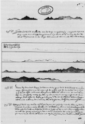
Detail maps of the region around Hirado and Nagasaki can be found in van der Aa (cat. no. 96), Reland (cat. no.66), Seutter (cat. no.71), and, of course, Siebold (fig.18).[3] Basing his work on a Japanese woodcut from around 1680, Kaempfer also completed a map of the city and environs (cat. no. 98), which Scheuchzer then used in 1727 for his English edition of Kaempfer's work (see cat. no. 99). Bellin reprinted it in 1763 (cat. no. l00). Dirck van Lier, the opperhoofd (trading-post director) from November 1661 to November 1662, sketched in his journal several profiles of the coast during the approach to Nagasaki, which are evidence of great talent and taste (fig. 22).[4] In addition, many works on Japan from Montanus (1669; cat. no. 92) to Siebold's NIPPON (1851) show maps and perspective drawings of Dejima, where there was - after business was concluded and the ships had departed - plenty of time for drawing.
JOURNEYS TO THE COURT
The "journey to the court" at Edo goes back to the time of Ieyasu, the first shogun of the Tokugawa dynasty, who granted the representatives of the VOC the right to an audience.[5] Of course, one had to show one's respect and display proper humility. In fact, however, the opperhoofd, who after all was merely a senior merchant, was enjoying a privilege that native merchants would not even have dared to dream of, for the latter stood at the lower end of the Japanese social hierarchy - lower even than the peasant class. The limited freedom of movement for the Europeans in Japan, the constant moaning of the merchants about their high costs, and especially the wishes of the shogun Tsunayoshi - as Kaempfer described them gradually reinforced the image in Europe of a "journey of tribute," to which the Dutch submitted themselves in the name of beloved profit. However, direct contact with the representatives of the central government was, nonetheless, important to the VOC. Connections were reaffirmed and immediate problems were settled. The refusal of an audience - as, for example, in 1627 and 1648 - was an alarm signal that was well understood and responded to through increased efforts at cooperation. After all, this journey - aside from all questions of politics, etiquette, and "face" - offered Europeans the only opportunity since the closing of Japan to escape their prison on Dejima for a time and to get to know the country and the people. It was carried out annually from 1633 until 1790, after which it took place every fifth year.
A visit to the ruling court - with its preparation, the trip, the arrival, and the audience - provided more drama than aimless wanderings in distant regions of the world. In the case of Japan, too, descriptions of journeys to the court are not at all rare. They had been put down on paper long before Kaempfer's History of Japan. The Japponische Reiss-Beschreibung (Description of a Japanese Journey) by Caspar Schamberger of Leipzig has, unfortunately, been lost.[6] It is highly probable, however, that in 1669 Schamberger bought a copy of Gedenkwaerdige Gesantschappen Der Oost-Indische Maatschappy in't Vereenigde Nederland (Memorable Delegation of the Dutch East-India Company) (cat.no.102),[7] which was published in Dutch as well as German and English, since "his" legation of 1649/50 is described there, as well as the two journeys to the court (in 1657 and 1659) by the opperhoofd Zacharias Wagener, a compatriot from Dresden.[8] Arnoldus Montanus extracted the detailed descriptions from the sources of the Iberian mission and the documents of the VOC, adorning them with all sorts of historical and cultural digressions. The illustrations are often grotesque, but if one separates the text from the addenda, the descriptions that remain are by and large accurate. In Scandinavia, we find a powerful and lively depiction of a stay in Japan from the pen of the Swede Olof Ericksson Willman, who came to Nagasaki in 1651.[9] Kaempfer, who was the physician at the trading post on Dejima from 1690 to 1692, had, of course, studied Montanus and taken up many of his ideas. Kaempfer's book set a standard that could not be ignored.[10] Of those who came later, only the Swede Thunberg[11] and, in the nineteenth century, von Siebold[12] of Würzburg achieved anything comparable. All three were physicians, who had nothing to do with trade and thus had more leisure to observe their surroundings than did the merchants employed by the trading post. A wealth of firsthand information was made available to them by way of their grateful Japanese patients, as well as the translators and the native physicians, who all had a keen interest in Western medicine.
Occasionally, one reads strong criticism of the Dutch merchants' limited interest in their host country, and in fact, the thirst for knowledge on the part of theJapanese was far greater than that of the Europeans. Nevertheless, many opperhoofd's names like Andreas Cleyer[13] and Isaak Titsingh[14] will have to suffice here - were said to be highly educated and committed. Unlike private research journals, their official daybooks naturally had to concentrate on the events that were significant to trade relations. Despite this, however, personal comments do regularly make their way in here, too, especially in trying circumstances. Thus, reading these dagregisters (daybooks) is not unproductive, and, together with the accounting information that was also recorded here, one does obtain a full picture of life in the Far East.
Before the journey to the court began, detailed preliminary deliberations for departure were necessary. Personnel were hired; dishes, crates, provisions, and much more were purchased. After a variety of departure procedures were completed, the legation finally got under way. As a rule, the stages were logged daily: the places where they took tea and lunch breaks, where they crossed rivers or toll bridges, and where they dropped anchor or finally found lodging. The accounts show the wages of the bearers, the number of horses necessary, all purchases, presents, and "tips." Occasionally, an assiduous opperhoofd even recorded the distances traveled. Such details were probably taken from the popular dôchûki (guidebooks), which described in detail the inns, prices for hiring bearers and horses, sights, and more. Kaempfer brought several of these guidebooks back to Europe.
After the forced removal of the VOC trading post from Hirado to the island of Dejima in 1641, the journey to the court quickly acquired a fixed form. For just over two decades, the section from Nagasaki to Hyôgo was covered by ship. The party continued by sea to Ôsaka and then travelled overland along the famous Tôkaidô road to Edo, the seat of the shogun. As the de facto ruler, the shogun was considered by the VOC to be Japan's "emperor," while the tennô (Emperor of Japan), who resided in Miyako (present-day Kyôto), was taken to be the religious leader. During the period when the settlement was in Hirado, the opperhoofd traveled accompanied only by a secretary, then later a junior merchant was added. Occasionally, a barber was part of the party. After Schamberger - as part of the entourage of a special legation - had created a great stir in 1649/ 50 with his salves and plasters, the surgeon was regularly taken along. This gave a strong impetus to the spread of Western medicine in Japan.
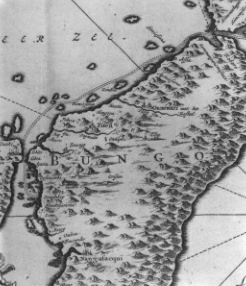
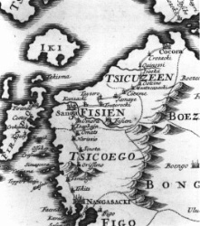
In November, the last Dutch ships left Nagasaki for Batavia. Until July, when the first sails appeared on the horizon with the favorable summer monsoon, there was little to do. In the early days, the party would set sail in mid-winter, circumnavigate Kyûshû to the north, enter the Inland Sea (Seto Naikai), and sail to Hyôgo. The route can be seen on the maps by Montanus (cat. no. 102; fig.23) and Jean-Baptiste Tavernier (cat. no.35) Owing to the stormy winds from the Asian continent, the journey to Shimonoseki was fairly difficult. Again and again, the not very seaworthy "barques" - as the Dutch called these vessels - were forced to drop anchor in sheltered bays and wait for better weather. Typically, this required six to eight days. Wagener's group had to fight its way through three and a half weeks in 1659 and nearly got into distress off the principality of Chikuzen. From then on, beginning with the return trip, they always took the land route via Kyûshû (see fig. 24). The date of the trip, too, eventually became fixed. Beginning in 1661, the departure took place, as a rule, on the fifteenth day of the first moon, which according to the Western calendar fell in February or early March. Large baggage was sent ahead by sea to Shimonoseki.
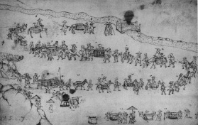
The allotment of accompanying personnel was considerable. Two samurai of the governor of Nagasaki were the "journey leaders" in charge; then there were representatives of the municipal police, senior and junior translators, and, in blue smocks with the insignia of the VOC, numerous cooks, servants, and bearers. Only the opperhoofd allowed himself the special luxury of being carried in a palanquin, an indulgence that was not actually his right. His countrymen were on horseback. Later, as one reads in Thunberg, they, too, rode in palanquins. Horses and bearers were swapped or increased en route, depending on the condition of the road and the nature of the goods being transported. When Frisius's legation of 1649 arrived in Edo, there were 24 Europeans, 310 Japanese, and 128 horses. Kaempfer's famous cavalcade of 1691 is said to have included roughly one hundred escorts in Kyûshû and one hundred fifty for the final stretches (fig.25). When Thunberg, the opperhoofd, and the latter's secretary departed in 1776, they were surrounded by nearly two hundred men; even Siebold in 1826 found himself under similar care. These were, nonetheless, still small groups in comparison with the monstrous processions that crossed the country when native feudal lords went on their travels.
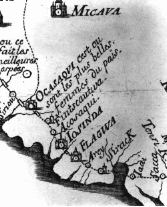
Sea travel was subject to the weather and the tides. Land travel was determined by lodgings and the distances that could be covered in a day. As a rule, the cooks and servants traveled ahead, in order to have meals ready for the group on arrival. Contacts with the population were not officially permitted, though spontaneous reactions could not be suppressed entirely. In the official and private travel diaries, the picture has several facets. There were scenes like that in Kurume, where the main street was completely empty as the procession passed through the city, but all the side streets were filled with locals, silently bowing. Another time, a Japanese official was clearly warning other travelers against any approach. Some of the Dutch complained about the isolation in the lodgings; occasionally, one even reads that the windows were nailed shut. Still, Thunberg found the back rooms to be the finest and most elegant part of the house; and it is not uncommon to see complaints of pestering boys and stubborn, begging "nuns" who refused to leave one's side for hours. A cheerful Siebold even praised the cleverness of his overseers, who avoided becoming witnesses to acts that were not permitted to the Dutch but could not be prevented. And how should one interpret the reference on Tavernier's map to "the most beautiful women in the country" in the small town of Okazaki (cat. no.35; fig.26)? The English reprint of 1680, incidentally, leaves out such frivolous comments.
After passing through the strait between Kyûshû and the main island of Honshû, preparations were made in Shimonoseki for the second stage by ship to Hyôgo, a port near Ôsaka. The route led through the relatively calm Inland Sea, which offered a picturesque view with its countless islets. Here, too, the maps were clearly more detailed than those of the hinterland. Typically, the party would drop anchor in a calm bay at evening. Very little has been written about shore leave. In Muro, the entire "train" would occasionally go into a bathhouse. This craving for water was not, however, very strong among Europeans. In deadly earnest, Kaempfer once contrasted the "superstitiously clean" Japanese with the "sensuous" Dutch. And Western noses were presumably equally desensitized in the centuries that followed.
From Hyôgo, the journey continued to the river Yodogawa and then upstream to Ôsaka - because of the shallows, the baggage was transferred into smaller vessels. Some groups took the land route instead. A mighty castle bore witness to the importance of this city, in which a courtesy visit was paid and gifts presented to the municipal governors and the castle-keeper; then written permission was awaited to continue the journey to Edo. This was issued by the shogun's representative in Kyôto, who is usually characterized in Dutch sources as the "High Judge," because he was responsible, among other things, for settling legal disputes.
The third and last section of the journey required more personnel and horses for the baggage. From Ôsaka, it continued to Kyôto, then to Lake Biwa along the 303-mile (488-km) long Tôkaidô road toward Edo. The fifty-three stations where the travelers were cared for and lodged have left many traces in literature and art. In the West, they became known primarily through Hiroshige's colorful woodblock prints. Even today, it is possible to let oneself be carried back to old times, for example, in the area around Tehara, near ôtsu, with its eighteenfoot (five-and-a-half-meter) wide, gently winding street, framed on both sides by pretty wooden houses. Every league (2.4 miles or 3.93 km) was marked by a small "one-league hill" and signposts provided orientation at crossings. Since heavy goods were conveyed by ship, there was almost no transport on wheels. There was a mixture of travelers of all classes. Some were on business, others were on pilgrimages or pleasure-trips, many were doing all three. Among them were runners, who, thanks to an ingeniously designed messenger system, conveyed letters from Edo to Ôsaka in only two or three days. Peddlers sold medicines; itinerant monks offered talismans, miracle cures, and exorcisms; certain "nuns" offered themselves. Everywhere entertainers attracted people. In the shops there were local products - straw sandals, tobacco, tea, and other refreshments. And as the day waned, women waiting in front of the door would drag the tired traveler into one of the station inns.
The Dutch and their retinue encountered several barriers along the way. Many of the rivers had no bridges. Then one either crossed by boat or engaged the services of "river crossers," who brought the travelers and their baggage to the other side on their shoulders or on special stretchers. Near Arai, the Dutch passed through one of the most important of the empire's seventy-six control stations, from which the government oversaw all travel and tried to spot suspicious movements. From here, they went in barques across the shallow bay to Maisaka. If the legation was unlucky, it would encounter the cavalcade of a feudal lord somewhere en route. Then it would have to step modestly aside and wait, and this could take some time. Occasionally, the members of the party were directed to different lodgings because of some noble person and could even be unexpectedly sent off to another establishment after they had settled in for the night. Mount Fuji, whose peak would still be covered with snow at this time of year, must have made a great impression on everyone. Its view signaled the most difficult endeavor: crossing the Hakone mountain range, which required well-rested horses, strength, and concentration. The last three stages to Edo are today all within the greater Tokyo region and worlds away from what these travelers saw then. Around thirty days would have passed since leaving Nagasaki.
By the beginning of the eighteenth century, Edo was already an enormous city with about a million inhabitants. Every year the Dutch stayed in the Nagasaki-ya, an inn in the district of Honkokuchô that had previously served as accommodation for the Portuguese. In 1642, the opperhoofd Jan van Elseracq described it briefly in his daybook. It was a building like a prison, next to the house of the innkeeper, accessible by a path some four feet wide and sixty feet long. After climbing the stairs, one found oneself in a room the size of eight "mats" (approximately 15 l/2 sq. yd. or 13 sq.m), where meals were usually served. A bedroom of the same size was next door. With its wardrobes and beds, it was too narrow to accommodate four or five people. The assistant and the barber could not walk upright in their room under the stairs and the others had even poorer lodgings. In the room facing the city, the head watchman lodged with four servants, so that no one could go in or out unobserved. In the rooms beneath the Dutch, two soldiers stayed with their servants. No visitors were allowed unless accompanied by a soldier.
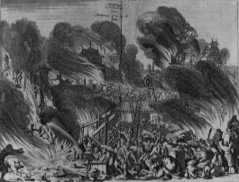
The wooden structures did not stand forever. The ravages of time saw to that - earthquakes and especially fires, which nearly every opperhoofd observed through his window, either in the immediate vicinity or at a distance. There were more than eighty large conflagrations in Edo during the 270-year rule of the Togukawa shogunate. Wagener's group barely escaped one of the most violent catastrophes, which reduced vast stretches of the city to ashes in 1657 and caused around a hundred thousand deaths. Montanus depicted it for a horrified public in a dramatic copperplate engraving (fig. 27). There is also evidence of seven fires in the Nagasaki-ya alone. Despite the frequent renovations and additions, the basic structure of the inn - which was run by the same family (Nagasakiya Gen'emon) for more than eleven generations - remained largely unaltered. The long, narrow hallway into the rear building and the lodgings on the third floor can easily be recognized in Kaempfer's description as well as in Thunberg's. Both authors made an effort at objectivity, though they had no doubt expected better accommodation. Siebold, who was less tolerant, referred to his lodgings in 1826 bluntly as a "miserable lodging for a legation."
During the occasionally rather long waiting period until the day of the audience with the shôgun, the translators and officials scurried about. Outstanding questions were resolved and it was decided which presents went to the "emperor" (i. e., the shôgun), the "crown prince," the "imperial councillors," the governors of Nagasaki, and other important personalities. Even today, one can still find among the papers of the VOC a precise inventory of the articles, quantities, prices, and recipients. At the same time, orders were taken for certain rarities, including maps and globes, which would be delivered the following year or the year after that and paid for at some later date. These items, too, can be identified from the bills of lading and account statements.
Though entry was prohibited to the general population, there were visitors in the house nearly every day. In addition to those who had access because of their positions, there were often sons and other relatives of "imperial councillors," "governors," etc., who wanted to look at the presents and the foreigners. As a rule, they were treated as generously as possible to Dutch delicacies and the always popular red wine. This cost something, of course, but information was gleaned in return. The trading-post physician was particularly sought after: many of the higher nobility who were suffering from injuries or illnesses called upon him. The Japanese court physicians, too, liked to seek him out to obtain information and medicines. Finally, certain craftsmen and traders had access in order to prepare the presentation of the gifts.
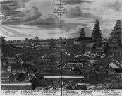
When the controversial problems had been settled and the appropriate length of time had passed, the day of the audience arrived. The castle in Edo, which had been built between 1603 and 1651, was among the most commanding fortresses in the world, with a ten-mile (sixteen-km) outer wall and an inner wall of some four miles (six and a half km) (fig.28). In comparison to the exertions required up to this point, the ceremony itself seemed somewhat anticlimactic. First, there was a wait for a while in a separate room. Then the opperhoofd was led into the reception hall. Sometimes his countrymen were allowed to watch the scene from the background; otherwise they had to make do with the antechambre. On a signal and the cry "Oranda Kapitan" (Holland captain), he demonstrated his respect by going down on his knees and bowing his head and upper body deeply. Perhaps he allowed himself to sneak a glance, but His Majesty sat behind a kind of screen made of rushes, so that hardly more than his silhouette was visible. And then everything was over. After another signal - several diaries mention a discreet tugging at his coat - the opperhoofd humbly crawled backward to the hall and then accepted from the Japanese their congratulations on a successful audience. Afterwards, the proceedings continued with a visit to the palace of the "crown prince" in another part of the expansive palace grounds, where a similar scene occurred. Often on the same day, a tour would be made of the residences of the "imperial councillors" to express proper gratitude. The lords, who were very conscious of their rank, made a habit of not being at home at the appointed time. Similar one-sided, unreciprocated attentiveness was paid to other dignitaries in the period that followed.
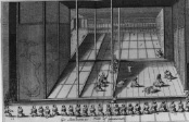
After the first main reception, Engelbert Kaempfer experienced a second informal act, in which the Dutch answered a variety of questions posed by the shogun, still hidden behind a screen. Finally, the whole thing turned into a pickelheringsreigen (buffoon's roundelay), with singing, dancing, drawing, and acting.[15] This sort of thing only occurred between 1680 and 1709, that is to say, during the reign of the shogun Tsunayoshi, a highly inquisitive, perhaps somewhat eccentric person. Kaempfer's description and illustration (fig.29), however, impressed itself on the European consciousness and even one hundred thirty years later, Siebold believed himself to be lucky that this "private show given by the Dutch" had "since been abolished." At many courts in the Near and Far East, however, the representatives of the VOC in Kaempfer's time encountered worse things. And European dignitaries, in the right mood, could certainly keep their end up.
In the days that followed, reciprocal gifts would arrive. Those of the "emperor" and the "crown prince" - usually precious silk kimonos - would be received at a special departure audience. They were valued in the West for being both colorful and comfortable; for a time, they were so sought after that the VOC had imitations made to meet the demand. Permission to depart was granted along with warnings not to bring Portuguese into the country nor to seize any Chinese junks, and with a request to report on all the important events of the world.
The legation returned home by the same route, but without the pressure of a deadline and in a noticeably better atmosphere. Temples were visited on the way, and the castle in Ôsaka was another of the regular stops on the program. Of course, the opperhoofds complained about the overly large number of bearers and horses that were only necessary because the Japanese escorts had made enormous numbers of personal acquisitions. It is difficult to imagine, however, that the businessminded Europeans would have departed without any souvenirs. Understandably, the bearers, who were hired on a daily basis, showed noticeably less eagerness on the return trip.
The journeys to the court found direct resonance in Montanus's map of 1669 (cat.no.102), followed by Tavernier in 1679 (cat.no.35) and Valentynin 1726 (cat.no.46).Montanus's influence on Tavernier is very clear. Both show the sea route around Kyûshû, which had already been abandoned by then (fig.23); the place names are also the same, for the most part. Valentyn, on the other hand, worked from other (VOC) sources. He shows for the first time the land route between Nagasaki and Kokura (fig.24). Nevertheless, Kaempfer was responsible for the greatest cartographic achievement of this period, when, with the help of a hidden compass, he secretly mapped the entire route.[16] In Kaempfer's overall map of Japan edited by Scheuchzer (cat. no.77A), we can find all the place names of the journey to the court, but there is no connecting line, so that one has to fall back on the route maps to follow the exact course of the journey (cat. no.103). Not until the adaptations by Tirion (cat. nos.78, 79) and Seutter (cat. no.80) is there any indication that Kaempfer was actually familiar with two different routes between Nagasaki and Yamaie on the island of Kyûshû.
EXPLORATIONS IN THE NORTH
Originally, most of the geographical information on the East Indies was collected and reworked in Holland. Beginning with governor-general Hendrick Brouwer's administration in 1632, however, Batavia developed into a second cartographic center for the VOC. Brouwer had made a name for himself as the discoverer of the southern route from the Cape of Good Hope to Batavia, which shortened the duration of the average voyage to the East Indies to six months. In addition to looking for faster and safer transport routes, the VOC undertook voyages of discovery - and not just to find new trading partners but to find urgently needed gold and silver. Because of the lack of suitable European goods that could be sold in the Far East, spices, porcelain, and precious woods had to be paid for with gold and silver. In the face of the undesirable flow of precious metals from the Netherlands and the long, risky transport routes, the VOC looked covetously toward the Iberian mines and ships in Central and South America. It also searched - with little success in Taiwan, South Africa, and Sumatra. Dutch tradesmen from Mexico, moreover, had brought rumors of a Spanish ship that had been blown off course by a storm and had landed east of Japan on the legendary Gold and Silver Islands. Step by step, the maps that had been taken over from the Iberians were improved. Matthys Hendricksz. Quast explored the Chinese coastal waters during his hunt for Portuguese silver ships from Japan. The aforementioned Visscher was only concerned with the Japanese archipelago, though his information also left its mark on the cartography of the area around Tonkin and Hainan. The renowned Abel Jansz. Tasman was to lead the two expeditions to the south on which the shape and nature of the Southern Continent (Terra Australis) were to be established.[17]
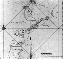
In Batavia, Brouwer was always accompanied by his successor, Antonio van Diemen. When Brouwer left office in 1636, he put in writing, at van Diemen's request, a series of recommendations for possible exploration and navigation. One of van Diemen's main efforts was the search for those Gold and Silver Islands, which were thought to be 400 miles east of Japan at a latitude of 37 degrees 30 minutes. Originally, the plan was to set sail from Japan, but that idea was abandoned in 1637. Orders came from Holland that the coast of Tartary where the large cities of Cambalu and Brema, reported on by Marco Polo, were thought to be - should be explored at the same time. In 1639, two ships put to sea from Batavia. Quast was the commander in chief, with Maerten Geritsz.Vries as second in command. Tasman was the captain on the other ship. Unfortunately, this voyage in the bleak waters east of Japan resulted in little more than the discovery of various islands, rather battered ships, and high losses due to dropsy and scurvy. The journal of their expedition can be examined in Teleki.[18] A manuscript map belonging to the VOC shows the "Quastian Islands" (fig.34).[19]
The first clear manifestations of the activities of the mapmakers in Batavia appear in the 1640s. Interestingly, one of these mapmakers was the aforementioned Zacharias Wagener, who was to direct the trading post in Japan in 1656/ 57 and 1658/59. He had refined his skills in Amsterdam in 1632 at the publishing house of Willem Jansz. Blaeu, before beginning work in Brazil for the Dutch West India Company. After transferring to the Dutch East India Company in Batavia in 1642 with the rank of adelborst, a sort of naval cadet, he rapidly rose to assistant and map-copyist.
In 1642, it was decided to make another exploratory voyage, this time direct to Tartary.[20] Since it was possible that in the north Japan was connected to the continent, a route was chosen to the east of the island archipelago. In early 1643, two ships were entrusted to the command of Vries: the flute Castricum,[21] captained by Pieter Willemsz. Knechtjes, and the yacht Breskens, under Hendrick Cornelisz. Schaep. On 20 May, however, the ships were separated by a violent storm southeast of Japan in the vicinity of the island of Hachijô-jima. The Castricum, with Vries on board, sailed along the Japanese coast and reached the southeast point of Ezo, present-day Hokkaidô. Keeping some way out to sea, Vries ran into fog and, without noticing that Ezo was now behind him, soon reached the Kurils (fig.30). There, between Etorofu (Iturup) and Urup, he discovered the "Straet de Vries" (Vries's name still being preserved in the Russian name Proliv Friza). He named the region to the south "Staten Landt" (Land of the [Dutch] States-General) and ostentatiously usurped the regions to the north - which appeared to be unpopulated and which he took to belong to North America - as "Companijs Landt" (Land of the [Dutch East India] Company). In the course of further cartographical explorations of the northwestern coast, he rediscovered the passage and now drew the "Staten Landt" as an island ("Staten Eylandt"). The eastern coast of Sakhalin was misinterpreted as the eastern coast of Ezo. Owing to the fog, they missed the strait between Sakhalin and Ezo, which was not recorded by La Pérouse until 1787 and is named after him. Unfavorable winds and thick fog caused the exploration to be called off in late July. The ensuing efforts to find the Gold and Silver Islands were fruitless, so they set off for home. Southeast of Japan they met up with the Breskens, which had likewise reconnoitered the southern Kurils but had not gone further than Sakhalin. In November both ships reached Taiwan. Though they had collected a great deal of geographical material, they had nothing that could please a good merchant. As a consequence, no further explorations of this kind were undertaken.
This is not, however, the full story. On the return trip, the Breskens had come too close to the Japanese Empire. After a storm toward the end of the July, the lack of drinking water, firewood, and fresh provisions drove them ashore near Yamada in Nanbu. The skipper Schaep and nine of his crew - the youngest of whom was only fourteen - were promptly taken prisoner and brought to Edo. The Japanese authorities of the time feared nothing more than the clandestine arrival of missionaries; and, in fact, the circumstances looked very suspicious. What was the ship looking for in these northern waters, far from the usual route? And why had it escaped on the open sea after its captain had been arrested? Did they really have nothing to hide? It required a considerable effort to prove that they were Dutch and to convince the authorities that they had no harmful intentions. In the second part of his book, Montanus described the fears of the Dutch and the interrogations, for which translators were specially ordered to come from Nagasaki.[22] Roughly handled Jesuits served as a demonstration of what could happen to them if they made false statements. They were interrogated again and again, and their answers were compared with their earlier statements.
Questions of cartography also came up repeatedly. So, in late September, Christovão Ferreira - a former missionary who had since been naturalized as Sawano Chûan and was at this time in the service of the imperial inspector Inoue Masashige - pulled out a map on Japanese paper. Schaep and the junior merchant Willem Bylvelt later wrote that it was a "flat globe." According to their account, it encompassed East and Southeast Asia and, to the astonishment of the Dutch, did not correspond to their conceptions of Tartary and Ezo. Ferreira now tried to prove that they were telling untruths. For, as this map showed, they could never have reached their destination in the manner they had described. Naturally, both of them denied this resolutely.[23] The "imperial councillor" Makino Chikanari later picked up on this exchange; he wanted to know how the Dutch presumed to find Tartary without a map. Schaep adduced his nautical instructions and the general information that could be found in books on Tartary. Their purpose was precisely to produce maps that they did not yet have. How was it, then, that there were maps of the world but no maps of Tartary? Schaep replied that (exact) maps only existed for regions they had already visited. When the persistent Makino was considering whether he should have the documents concerned brought from Nagasaki, it was explained to him that these would be land maps, not nautical charts (with exact coastlines). There could be none of the latter for Tartary, since no European ship had been there yet. The Dutch gave their word and said they would submit themselves to any punishment the Japanese wished if it proved to be untrue.[24]
Only after a great deal of anxiety and with the assurances of the opperhoofd were the prisoners eventually handed over to the VOC. The Japanese did not neglect to point out the special mercy which was being shown, despite the serious transgressions that had been committed. It was clear that this required an extraordinary demonstration of thanks from the Dutch.
A description of Edo and its natives, based on the material collected by the Castricum, appeared as early as 1646.[25] A journal by Schaep and Bylvelt and sections of the journals of the Dejima trading post describe their experiences in captivity, including the interrogations. Montanus studied and summarized both sources.[26] Kaempfer, too, on Dejima prepared an excerpt of Schaep's notes.[27] Nicolaas Witsen, a scholar and mayor of Amsterdam, included Vries's explorations in his Noord en Oost Tartaryen (North and East Tartary), which was published in 1692.[28] The logbook of the Castricum was published in 1858 by Leupe.[29] In addition, several manuscript maps are known that are based on the original by Vries (figs.30, 76).
The discoveries of Vries's expedition were first disseminated in printed form as part of the world map by Joan Blaeu (1645/ 46; fig.77) . Without a doubt, the view of Ezo presented here contributed a new grotesque form to the cartography of the Japanese archipelago. Still, when one takes into consideration the course of the voyage and the conditions under which the data was collected, it is difficult to reproach Vries and his men. The influences of his interpretation of Ezo's coastline continued into the nineteenth century.[30] Interestingly, even on maps in which Ezo has more accurate outlines or where it is missing completely, we can find in the northwestern part of Honshû - along the route of the expedition - a series of Dutch names like "Ronde Holm" (Round Bar/Beam), "Princen Eylandt" (Prince Island), "Witte Hoek" (White Peak), "Walvis Bocht" (Whale Bay), "Schilpats Eylandt" (Turtle Island), "Hoge Tafel berg" (High Table Mountain), "Croon berg" (Crown Mountain), etc. Occasionally, there are only a few such names, such as "Walvisbocht" on Bucelinius's unassuming map (cat. no. 56). In other cases, one can see the entire list, providing a stark contrast to the surrounding Japanese names: Martini (cat. no.38), Coronelli (cat. nos. 43, 44), Valentyn (cat.no.46), Chatelain (cat.no.61), Sayer (cat.no.87), and Cassini (cat. no. 53).
Footnotes:
Literature:
- Arnold, Christoph: Wahrhaftige Beschreibungen dreyer mächtigen Königreiche, Japan, Siam und Corea, Nürnberg 1672.
- Hammitzsch, Horst: Japan-Handbuch, Stuttgart 1990.
- Imai, Tadashi: Engelbert Kaempfer und seine Quellen, in:
- Engelbert Kaempfer zum 330. Geburtstag. Gesammelte Beiträge zur Engelbert-Kaempfer-Forschung und zur Frühzeit der Asienforschung in Europa, hrsg. von Hans Hüls und Hans Hoppe, Lemgo 1982, S. 63-82.
- Kapitza, Peter: Japan in Europa, München 1990.
- Kraft, Eva S.: Andreas Cleyer. Tagebuch des Kontors zu Nagasaki auf der Insel Deshima 20. Okt. 1682 - 5. Nov. 1683. Bonner Zeitschrift für Japanologie, 6, 1985.
- Montanus, Arnoldus: Gedenkwaerdige Gesantschappen Der Oost-Indische Maatschappy in 't Vereenigde Nederland, aan de Kaisaren van Japan dam 1669 (=Montanus 1669 A)
- Montanus, Arnoldus: Denckwürdige Gesandtschafften der Ost=Indischen Gesellschaft in den Vereinigten Niederländern an unterschiedliche Kayser von Japan, Amsterdam 1669. (Montanus 1669 B)
- Michel, Wolfgang: Zacharias Wagner und Japan (I) - Ein Auszug aus dem Journal des 'Donnermanns', in: Dokufutsu bungaku kenkyû, Nr. 37, Fukuoka 1987, S. 53-102.
- Michel, Wolfgang: Caspar Schambergers Reisen in Japan, in: Dokufutsu bungaku kenkyû, Nr. 45, Fukuoka 1992, S. 1-85.
- Schilder, Günter: The so-called 'Atlas Amsterdam' by Isaak de Graaf of about 1700. A remarkable cartographic document of the Dutch East India Company, in: Vice-Almirante, A. Teixeira da Mota in Memoriam, Vol. 1, Lissabon 1987, p. 133-151.
- Teleki, Paul Graf: Atlas zur Geschichte der Kartographie der japanischen Inseln, Budapest 1909. (Nachdruck Nendeln, 1966)
Thunberg, Carl Peter: Karl Peter Thunbergs Reise durch einen Theil von Europa, Afrika und Asien, hauptsächlich in Japan in den Jahren 1770 bis 1779, Aus dem Schwedischen frey übersetzt von Christian Heinrich Groskurd, Berlin 1794. (Nachdruck Heidelberg 1991, hrsg. und eingeleitet v. E. Friese) - Thunberg, Carl Peter: Voyages de C. P. Thunberg au Japon, Paris 1796.
- Toyama, Eiji: Kindai no on-in, kokugôshi kôza, Bd. 2: on-in-shi, moji-shi, 1973.
- Van der Velde, Paul / Bachofner, Rudolf: The Deshima Diaries Marginalia 1700 – 1740. The Japan-Netherlands Institute, Tokyo 1992.
- Wenck, Günther: Japanische Phonetik, Vol. 1-4, Wiesbaden 1954-1959.
- Willman, Olof(f) Ericksson: Een kort Beskriffning uppå trenne Re(e)sor och Peregrinationer sampt Konungarijket Japan..., Wisingsborgh 1667.
- Zandvliet, Kees: Zacharias Wagenaer 1614-1668. A life in the Service of the Dutch East India Company and the Dutch West India Company, in: The Dutch East India Company in the 17th Century, Life and work of Zacharias Wagenaer (1614-1668), Holland Village 1987.
- Zandvliet, Kees: Golden opportunities in geopolitics: Cartography and the Dutch East India Company during the lifetime of Abel Tasman, in: W. Eisler, B. Smith. Terra Australis, Art Gallery of New South Wales, 1988, p. 67-84.
